Application Areas--Wireless Coverage Maps
Services
• Cellular Coverage Maps
• WiFi Coverage Maps
• Wireless Coverage Maps (receive signal strength, maximum downlink and uplink data-rates, LTE RSRP/RSRQ, etc.)
• Site/path mapping (GIS)
• Site/path surveys
• Detailed RF propagation maps and performance statistics, including annual and worse month availabilities as a function of location and time variability with a given confidence (e.g., 90%)
Discussion
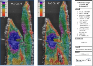
We typically use 1/3 second terrain elevation profiles, and can also use clutter data for trees, buildings, and other above ground objects. If needed, we can use LIDAR clutter data with better than 1 m height resolution, and can specify the appropriate RF properties for a particular clutter type, such as “wet evergreen forest”, “deciduous forest”, urban buildings, residential structures, etc. Accurate clutter data for point-to-multipoint coverage maps are especially important for the higher carrier frequencies where tree and building attenuation can be especially high. As an example of this point, see the first two figures on the left top of the wireless coverage maps project examples page, where we show the RF coverage for the exact same location, basestation, and antennas with and without above ground clutter data.
For cases where it is required to know the in-building RF penetration from an outdoor macro cell or small cell, we can also use iBwave to model the building structure and estimate indoor signal levels, maximum data rates, signal-to-noise ratios, interference, and so on using a color-coded coverage “heat” map for each building floor.
