Application Areas--Microwave Backhaul/Point-to-Point Links
Telecommunications, Carrier and Enterprise Service Providers, Cellular Backhaul, Carrier Backhaul, High Frequency Trading (HFT), Homeland Security, Public Safety, and Government.
Services
• Microwave backhaul design, FSO Link design, MMW link design, microwave backhaul consulting, wireless consulting
• Point-to-point link designs: HF, VHF/UHF, microwave, millimeter-wave (MMW), and Free Space Optics (FSO)
• Frequency coordination/interference analysis
• FCC licensing/International licensing
• Low latency microwave designs
• Site/path GIS mapping
• Site/path field surveys, including line-of-sight (LOS) studies
• Detailed propagation statistics, including annual and worse month availabilities for point-to-point microwave/millimeter-wave networks
• Total network system reliabilities based on path availabilities, equipment Mean-Time-Between Failure (MTBF) and Mean-Time-to-Repair (MTTR)
• RF multipath analysis and mitigation
• Challenging over-the-water paths using spatial diversity • Hybrid millimeter-wave (MMW) and Free Space Optics (FSO) link availability/reliability analysis
• FSO atmospheric attenuation statistics using 1 or 5 minute airport visibility data (FSO fog attenuation)
• RF and FSO link budgets and availability/reliability calculations • Regulatory and spectrum due diligence
Discussion
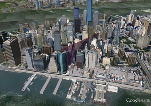
SpectraNet has been doing microwave backhaul design for the major US cellular carriers and enterprise service providers for over 15 years. Using judicious choice of network topology, radios, frequencies, and antenna sizes, we find the right balance to exceed service level agreement requirements while minimizing network costs. Microwave backhaul links can be imported into Google Earth to show line-of-sight potential which includes a visual look at Fresnel zone obstructions–this greatly decreases time spent in the field doing site and path surveys. We use 3D building data for urban deployments, and a combination of 1/3 second terrain elevation data with clutter for suburban and rural point-to-point designs. Clutter can be high resolution/high accuracy LIDAR data to accurately depict tree and building heights. SpectraNet has extensive databases of tower and building information for the US, and a large database of radio, antenna, and waveguide/coax specifications. We provide detailed site survey and path survey forms based on link designs, and also provide target receive signal levels (RSL’s) for installers.
